| Schwierigkeit |
mittel
|
|
Aufstieg
|
537 hm |
|
Abstieg
|
539 hm |
| Tiefster Punkt | 1008 m |
| Höchster Punkt | 1547 m |
|
Dauer
|
3:34 h |
|
Strecke
|
9,5 km |
HPB Viehhofen: Hinterglemm & The Wetterkreuz

Quelle/Autor: Holiday Property Bond Walks

Foto: Holiday Property Bond Walks, Holiday Property Bond Walks
Die Tour
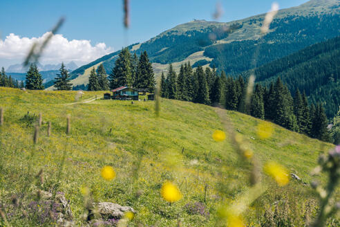
A good walk high on the valley side above Hinterglemm and Saalbach, using the cabin lift to reach a height of 1,480m. (4,859ft). The Wetterkreuz is a shrine situated on a broad col at 1,663m. (5,458ft).
A good walk high on the valley side above Hinterglemm and Saalbach, using the cabin lift to reach a height of 1,480m. (4,859ft). The Wetterkreuz is a shrine situated on a broad col at 1,663m. (5,458ft).
The paths leading to the Wetterkreuz have some narrow but generally attractive sections. A diversion to include the peak of the Reiterkogel, 1,8178m. (5,967ft)(turn left about half a mile after leaving the cabin lift top station) is a good extension to the basic route. The return route reaches the valley road about half way between Hinterglemm and Saalbach, then using the riverside track to return to the starting place.
Walk
From the top station follow the signpost for ‘Reiteralm ½ Stunde’, heading down a rough unsurfaced roadway to the Sportalm restaurant. Turn left for ‘Reiteralm and Wetterkreuz 13’. Pass the bottom station of a ski lift.
1. As the roadway bears to the left, turn right in 20m over a stile, to follow a grass path signposted to ‘Reiteralm’, rising steadily. Pass a small log farm building, cross a stream on a bridge, go over more stiles and pass a seat before reaching an unsurfaced roadway. Go straight across to continue; there is a sign. (However, should this part of the path be blocked by piles of brushwood, turn left along the roadway, pass a reservoir and rise to join the main roadway, turning right to continue). The path continues roughly parallel with the roadway above almost all the way to Reiteralm. The extensive views include the Schattberg (walk 5) across the Glemm valley. Pass under ski lift cables to reach the Reiteralm buildings.
2. After passing the buildings, go left, uphill passing a ‘Wetterkreuz’ signpost. Pass a farm building, go up to a stile and another ‘Wetterkreuz’ sign. Turn left along a little path rising through pine forest, with abundant bilberries. The path is steep but is easy to follow, with red waymarks, some rather faded. An open section allows views of Saalbach. Rise steadily along the bottom of a shallow valley with a tiny stream on the right to reach a prominent signpost and the Wetterkreuz shrine on its broad col. The hill to the left is the Reiterkogel.
3. Return towards the signpost, bearing left along a minor path just below the edge of pine trees; there are red waymarks. Go over a stile and cross some wet ground before joining another path. Turn right to descend steadily, passing a ‘Saalbach’ sign on a tree. Pass another junction, staying with the main track. Pass a gate and a tiny stream.
4. At a signposted junction, ‘Seiden’ stay with the main track, which soon zig zags steeply downhill, with the valley road now in view below. Descend through a meadow to a gate/stile, followed by a rather unpleasant loose stone track. Pass between buildings and across the front of the Pension Seig of, bearing right to reach the valley road.
5. Go straight across, cross the bridge over the R.Saalach and turn right, along the riverside track (reversing the route in walk No. 7) to walk gently back to Hinterglemm, crossing the road and passing across the front of the Maria Theresa Hotel.
Click here for further details about HPB Viehhofen; where 7 holiday units form the perfect retreat following a day's skiing or walking in an area of inspiring natural beauty.
Info
Karte
Details
|
Kondition
|
|
| Technik |


